The displacement of residents in Northern Saskatchewan due to seasonal flooding is not an isolated meteorological event but the predictable output of a rigid hydrological system meeting a volatile climate envelope. Surface-level reporting often focuses on the immediate human interest of evacuation; however, a strategic analysis reveals that these displacements result from three intersecting vectors: Precambrian Shield geomorphology, the failure of isolated infrastructure nodes, and the "basin-lag" effect inherent to the Churchill River system. Understanding these mechanics is the only way to move beyond reactive emergency management toward structural resilience.
The Geomorphic Constraint: The Precambrian Shield and Zero Infiltration
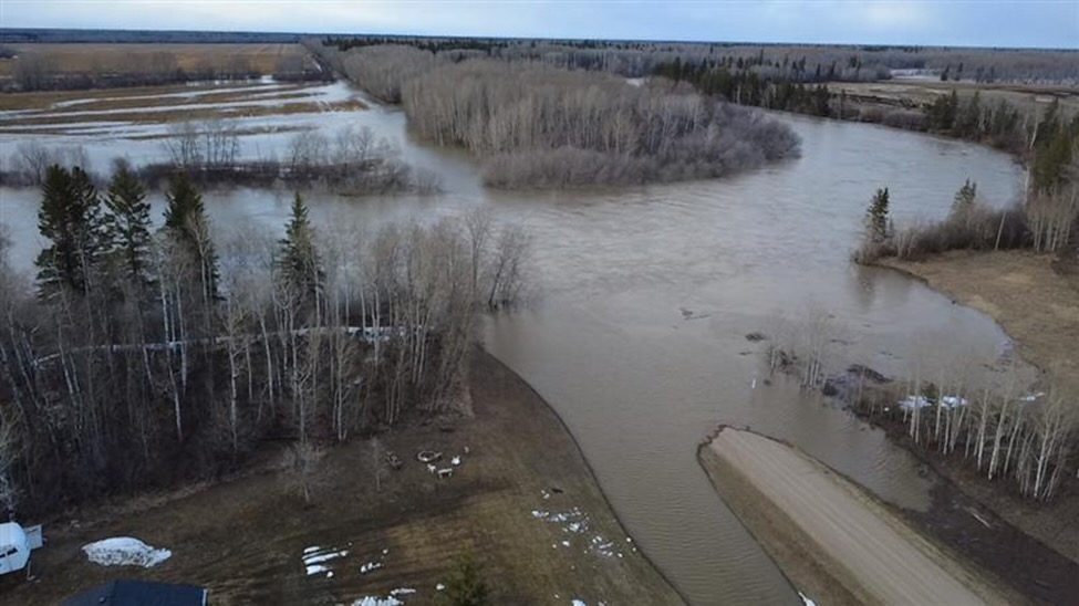
The primary driver of flooding in Northern Saskatchewan is the geological composition of the region. Unlike the southern grain belt, which features deep topsoil capable of significant moisture absorption, the north is defined by the Canadian Shield.
- Impermeable Basins: The presence of exposed igneous and metamorphic rock creates a near-zero infiltration rate. Precipitation and snowmelt have no vertical escape path into deep aquifers, forcing 100% of the volume into horizontal runoff.
- Storage Saturation: The region is a patchwork of shallow muskeg, peat bogs, and interconnected lakes. These act as natural reservoirs, but they possess a finite "spill point." Once the muskeg reaches its saturation threshold, any additional millimeter of rainfall translates directly into a rise in lake levels.
- The Runoff Coefficient: In urban planning, a concrete parking lot has a runoff coefficient near 0.95. Large swaths of Northern Saskatchewan operate at similar levels during peak melt or heavy rain events, effectively functioning as a natural drainage grate for the entire Boreal Shield.
The Churchill River Basin Lag Effect
Public perception often assumes that if the sun is shining in a community like Sandy Bay or Ile-a-la-Crosse, the flood risk is diminishing. This ignores the temporal lag of the Churchill River drainage basin, which covers approximately 280,000 square kilometers.
The "Flood Pulse" travels with a calculable velocity. Water falling in the eastern slopes of the Rocky Mountains or the Alberta foothills enters the Beaver River system and eventually feeds the Churchill. This creates a multi-week delay between the weather event and the peak water level in downstream Saskatchewan communities.
- Cumulative Loading: Flooding occurs when the local snowmelt peak coincides with the arrival of the upstream "pulse."
- Volume vs. Velocity: Because the terrain is relatively flat once the water hits the lake systems, the velocity of the water decreases while the volume builds. This results in "backwater effects" where downstream bottlenecks cause water to stack up in upstream lake basins, flooding communities that are geographically distant from the primary river channel.
The Infrastructure Fragility Matrix
The crisis of displacement is fundamentally a failure of the built environment to interface with the hydrological reality. In Northern Saskatchewan, this fragility is concentrated in three specific areas:
- Linear Asset Vulnerability: Most northern communities are served by single-access roads. These roads often traverse low-lying muskeg. When water levels rise, the "saturation of the subgrade" occurs long before the road is actually overtopped. Once the soil beneath the asphalt loses its shear strength, the road becomes structurally unsound for heavy emergency vehicles or supply trucks, necessitating evacuation even if the town itself remains dry.
- Hydroelectric Regulation Conflicts: The Reindeer Lake and Sandy Bay areas are influenced by the Whitesand Dam and the Island Falls hydroelectric station. While these structures offer some degree of flow regulation, their primary mandate is power generation, which requires maintaining high reservoir levels. This reduces the "buffer capacity" available to absorb sudden inflows from extreme weather, creating a tension between economic utility and flood mitigation.
- Septic and Water Treatment Overload: In many northern settlements, the water table sits inches below the surface. A flood event of only 0.5 meters is sufficient to inundate septic fields and compromise shallow-well intakes. The evacuation is frequently triggered not by the threat of drowning, but by the collapse of the sanitary barrier.
Quantifying the Economic Displacement Cost
Analyzing the cost of Northern Saskatchewan flooding requires looking past the immediate expenditure of the Provincial Disaster Assistance Program (PDAP). The true cost function is a combination of:
- Logistical Premiums: The cost of air-evacuating a community of 500 people is exponentially higher than a bus evacuation in the south. The lack of all-weather road redundancy forces a reliance on high-cost aviation assets.
- Educational Deficit: Displacements occurring in the spring coincide with the end of the academic year. The disruption to K-12 education in Indigenous communities, which already face systemic hurdles, creates a long-term human capital cost that is rarely quantified in flood reports.
- Asset Degradation: Repeated "minor" inundation of Boreal housing stock leads to chronic mold issues. Because these homes are often on Crown land or within First Nations jurisdictions with complex insurance structures, the capital to perform deep remediation is often absent, leading to a permanent reduction in the northern housing stock.
The Fallacy of "One-in-a-Hundred-Year" Events
A significant error in current provincial strategy is the reliance on historical return periods. The 1:100-year flood metric is a static calculation based on 20th-century data. The current climate trajectory has shifted the probability distribution.
The "Boreal Squeeze" is occurring, where the northern forest experiences higher-intensity short-duration rainfall events. The mechanical result is a "Flashy Basin" response. Instead of a slow, predictable spring rise, communities now face rapid-onset flooding that bypasses traditional early-warning timelines.
The hypothesis that these are "unprecedented" events must be replaced with the data-driven reality that the baseline has moved. The hydrology of 1970 is no longer a valid reference point for the infrastructure of 2026.
Strategic Reorientation: Hardening the North
To mitigate the recurring cycle of displacement, the provincial and federal frameworks must shift from disaster relief to aggressive adaptation.
- Subgrade Elevation of Primary Arteries: Highway 102 and Highway 135 require systematic elevation. Raising the roadbed by 1.5 meters using rock-fill from the Shield itself provides a permanent levee system and ensures that the "sanitary barrier" for the community remains intact.
- Decentralized Water Treatment: Moving away from centralized, low-lying water plants to modular, elevated treatment units reduces the likelihood of "sanitary evacuation."
- Inter-Provincial Basin Management: Saskatchewan must integrate its flow-monitoring data more tightly with Alberta’s mountain runoff sensors. This provides an additional 7–10 days of lead time, allowing for staged, non-emergency mitigation rather than panicked airlifts.
The focus must remain on the physics of the water and the chemistry of the soil. The Shield does not forgive poor engineering, and the Churchill River does not respect jurisdictional boundaries. Until the infrastructure reflects the geomorphology of the Boreal, the cost of displacement will continue to escalate as a fixed tax on northern life.


