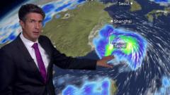
A monster doesn't just disappear when it loses its eye. That's the mistake people make when they look at the latest satellite images of Typhoon Bavi. Earlier this week, Bavi was a terrifying Category 5 super typhoon, screaming across the Pacific Ocean with sustained winds of 290 kilometers per hour. It absolutely battered the U.S. territory of Rota, ripping up water systems and knocking out electricity.
Now, the storm has weakened to a moderate or Category 1-level typhoon as it pushes toward East Asia. It looks lopsided on radar. Dry air has eaten away at its northern half, and heavy wind shear has knocked it off balance. Read more on a connected issue: this related article.
But don't let the drop in wind speed fool you. Bavi has undergone multiple eyewall replacement cycles. What does that mean in plain English? The storm's core collapsed and rebuilt itself into something much broader. It's a massive, water-logged giant stretching nearly 1,000 kilometers wide—roughly the entire width of France.
Because it's so wide, it doesn't need to make a direct landfall to cause absolute chaos. Taiwan, Japan's southwestern islands, and eastern China are all directly in the crosshairs of a massive moisture machine. More journalism by Al Jazeera explores related views on this issue.
The Geography Trap making Taiwan the Main Target
If you look at the raw track maps, Bavi isn't even expected to make landfall on Taiwan. It's forecast to skirt just north of the island. In a standard storm, that might mean a windy weekend and some heavy rain. Not this time.
Taiwan has a massive central mountain range. When a sprawling, lopsided storm like Bavi approaches from the east, those mountains act like a giant wall. The peaks force the storm's warm, humid air upward rapidly. This process, known as orographic lift, effectively squeezes the typhoon like a wet sponge.
Forecasters at Taiwan's Central Weather Administration are sounding the alarm. They're warning that parts of north-central and mountainous Taiwan could see up to one meter (3.3 feet) of rain. Even worse, more than a foot of that water could drop in a single 12-hour window overnight. That kind of intense, localized downpour makes catastrophic landslides and flash floods almost a certainty.
The island isn't taking chances. The government has already evacuated well over 1,000 people from vulnerable mountainous zones along the eastern coast. Financial markets are closed, workplaces have shut down across Taipei and northern regions, and the defense ministry has placed 29,000 soldiers on standby for emergency rescue operations. Even tech giant TSMC had to delay its highly anticipated monthly sales release because of the disruptions.
Japan's Southern Islands Face a Double Threat
Before Bavi even gets close to mainland China, it has to roll through Japan's Sakishima Islands, including Ishigaki and Taketomi.
For the people living there, it's a frantic race against time. Supermarket shelves on Ishigaki have been stripped bare of essentials like instant noodles. Residents are stringing up windproof nets and taping down windows to survive gusts expected to hit between 80 and 95 mph.
It's not just about the wind. The sheer size of Bavi means it creates massive wave action across the ocean. Ferry networks—the actual lifelines connecting these remote islands—are completely shut down. Hundreds of flights across airlines like Japan Airlines and All Nippon Airways have been grounded, leaving thousands of tourists stuck in hotels, waiting out a storm they didn't see coming.
China's Eastern Seaboard Braces for a Weakened but Saturated Remnant
By late Saturday, the storm is projected to make landfall along China's eastern Zhejiang province, likely near the major hub of Wenzhou.
By the time Bavi hits the mainland, its sustained winds will have decayed significantly. But the rainfall numbers are still incredibly dangerous. General estimates suggest 7 to 15 inches of rain will drench Zhejiang, Anhui, and Jiangsu provinces.
The timing is awful. Eastern and southern China are already reeling from recent severe weather, including a catastrophic dam breach and deadly tornadoes in Hubei province triggered by the remnants of Typhoon Maysak. The ground is already saturated. Rivers are already high. Adding another massive tropical system to the mix is a recipe for severe urban flooding.
There's another weird wrinkle to watch out for. Because Bavi has so much spin, or vorticity, locked into its lopsided remnants, meteorologists warn that isolated tornadoes could spin up across eastern China as the system moves inland.
The Climate Reality We Can't Ignore
We have to talk about why this keeps happening. Bavi is the third tropical cyclone to reach Category 5 intensity already this year.
The western Pacific Ocean is basically sitting on a powder charge right now. Marine heat waves are gripping about 16% of the world's oceans, and the Pacific is home to the absolute largest hotspot. Sea surface temperatures are hovering around 30 degrees Celsius (86 degrees Fahrenheit). According to data from Climate Central, these extreme ocean temperatures were made up to 80 times more likely by human-caused climate change.
On top of that, a building El Niño event is shifting where these storms form. Typhoons are birthing further out east in the Pacific. That gives them thousands of miles of open, boiling water to soup up their engines before they ever hit land. It's exactly why Bavi exploded into a Category 5 monster so quickly.
If you are living anywhere in northern Taiwan, the southwestern Japanese islands, or along the coastal provinces of eastern China, do not look at the downgraded "Category 1" or "moderate" labels and think you are safe. This is a water disaster waiting to happen.
Secure your immediate surroundings, map out your local evacuation routes to higher ground, and stock up on clean drinking water immediately. Water, not wind, is the real enemy with this storm. Stay off the roads as the core passes, and don't underestimate a lopsided typhoon.


