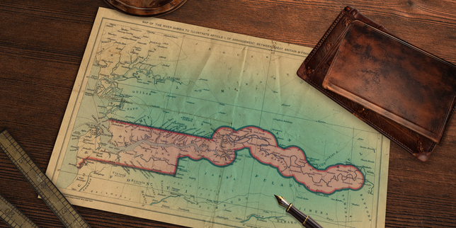
The map makes no geographic sense.
If you trace the coastline of West Africa, your finger drops down through the sprawling expanse of Senegal, a massive nation that curves like a protective shoulder around a smaller, defiant neighbor. Then, suddenly, the map pinches. A thin blue scar cuts horizontally across the continent, slicing deep inland from the Atlantic Ocean. Following that scar reveals a country that is barely a country at all on paper. It is a long, slender sliver of land, rarely wider than thirty miles, carved entirely along the banks of the Gambia River.
Look closely at Senegal. It wraps around this narrow corridor from the north, the east, and the south. It surrounds it completely, like a giant hand gently closing around a slender pen.
Standing on the dirt road near the border village of Amdalai, the absurdity becomes physical.
There are no mountains here to justify a natural barrier. No dramatic canyons, no impassable deserts, no ancient linguistic chasms that forced two peoples apart. The earth is flat, choked with dry scrub and scattered baobab trees that stand like ancient, silent witnesses to a strange political amputation. A farmer tending to his peanut harvest just twenty feet from the frontier speaks the exact same Wolof language, eats the exact same domada stew, and shares the exact same family lineage as the man plowing the field directly across the invisible line.
Only a painted wooden pole and a bored border guard separate them.
Why does this narrow, river-bound nation exist in the belly of a much larger giant?
To find the answer, we have to step backward through centuries of gunpowder, sailing ships, and bitter European rivalry.
The Cartography of Spite
History is rarely polite. Most modern borders are not drawn by anthropologists studying cultural harmony; they are drawn by exhausted men sitting in damp European drawing rooms, arguing over trade routes with inkwells and rulers.
In the seventeenth and eighteenth centuries, the Gambia River was the superhighway of West Africa. It was deep, navigable for hundreds of miles inland, and flanked by fertile soil. British merchants realized early on that controlling this river meant controlling the interior trade of slaves, gold, and timber. They established outposts along its banks, clinging tenaciously to the water's edge.
Meanwhile, French ambitions swirled across the wider region. France colonized vast swaths of West Africa, swallowing up what is now Senegal, Mali, Guinea, and beyond. They wanted a contiguous empire. They looked at the British enclave clinging stubbornly to the narrow riverbanks and ground their teeth in frustration.
Negotiations happened. Maps were shuffled. Proposals were floated to trade the British river strip for French territories elsewhere on the continent. But the British held fast to their profitable corridor. By the time the colonial scramble for Africa was codified, the riverbanks remained under the British Jack, while the surrounding savannah fell to the French Tricolor.
(Note: This colonial division is a classic historical mechanism of divide-and-rule, where European powers deliberately fractured homogenous populations to secure localized commercial dominance.)
When independence movements swept the continent in the mid-twentieth century, these arbitrary lines hardened into sovereign walls. The people living along the river suddenly found themselves citizens of a micro-state, while their cousins across an invisible boundary became citizens of a regional powerhouse.
Geography had played a cruel joke. Senegal was left fractured, its southern region of Casamance physically cut off from the capital of Dakar by a foreign country. To drive from northern Senegal to southern Senegal without a passport requires a massive detour or a reliance on a ferry that tests the limits of human patience.
The Rhythm of the River Life
Life inside the pencil-thin borders of The Gambia moves to a very specific, hypnotic rhythm.
Water defines everything. The Gambia River is the pulsating heart of the country, a tidal estuary that breathes in the Atlantic salt and exhales fresh water deep into the interior. On any given morning, wooden pirogues draped in bright blue and yellow paint push off from muddy banks. Fishermen haul in silvery bonga fish while women gather on the shore, balancing heavy plastic basins on their heads with effortless grace.
It is a country of intense warmth. Not just the dry, suffocating heat of the dry season, but the profound, disarming hospitality of the people. They call it aisha, a cultural code of welcoming strangers that runs deeper than any law.
Yet, the geopolitical reality casts a long shadow over daily survival.
Consider what happens to a truck driver attempting to move goods from the northern port of Banjul down to the isolated Casamance region. He loads his timber or bags of rice. He drives south. He hits the border. Papers must be stamped. Fees must be paid. Delays stretch from hours into days. The physical proximity is absolute, but the administrative distance is immense.
Smuggling becomes an unspoken economic lifeline. Because tariffs and taxes differ between the two nations, consumer goods constantly leak across the porous frontiers under the cover of night. Petrol, sugar, and electronics flow back and forth across dirt tracks in the bush. Border guards play an eternal game of cat-and-mouse with local traders who know every hidden footpath through the scrub.
For decades, political leaders have recognized the friction. In the early 1980s, the two nations briefly entered a political union known as the Senegambia Confederation. It was an ambitious attempt to weld the fractured pieces back together, integrating military, economic, and monetary systems.
It collapsed.
National pride is a stubborn thing. Leaders in Banjul feared being swallowed whole by their giant neighbor, losing their distinct identity, their English common law legal system, and their sovereignty to francophone dominance. Senegal, frustrated by logistical bottlenecks and diverging political trajectories, grew weary of carrying the weight. The confederation dissolved, leaving the map exactly as it was: a hand holding a river.
Bridges Across the Divide
Change comes slowly in West Africa, but it comes.
For generations, crossing the lower stretches of the Gambia River meant queuing for hours at the Banjul-Barra ferry terminal—a chaotic, sweltering crucible of hawkers, bleating sheep, broken-down trucks, and rusted vessels that frequently broke down. It was a physical bottleneck that choked national development.
Then, concrete and steel finally pierced the horizon.
The Senegambia Bridge, spanning the broad waters halfway up the country, opened as a monument to regional pragmatism. Standing on its deck today, watching heavy freight trucks rumble effortlessly from Senegal over the river and back into Senegal, you can feel the pressure easing. It is a physical zipper sewn across the water, holding two estranged halves of a region slightly closer together.
It does not erase history. It does not redraw the map. The Gambia remains tucked firmly inside the embrace of Senegal, a sovereign nation defined by the stubborn width of a single river valley.
The border guards still check passports at Amdalai. The families still farm the same soil on opposite sides of a painted pole. But as the sun dips below the Atlantic, casting long, bruised purples and golds across the water, the artificiality of the line fades away.
The river keeps flowing. The people keep laughing, sharing meals across thresholds that politicians drew on parchment centuries ago. The map remains broken, but the life inside it refuses to be contained.