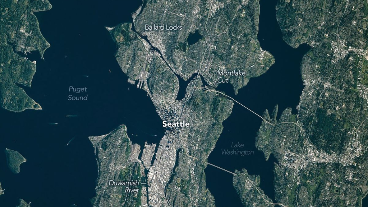
Look at satellite imagery of Seattle, and you immediately spot the scars. A deep, fjord-like trough holds Puget Sound. Lake Washington sits parallel to it, cradled in a twin groove running north to south. From hundreds of miles in orbit, the Pacific Northwest metropolis looks like a sculpted basin carved by a single, deliberate stroke. That shape is not an accident of nature, nor is it merely a backdrop for glass-and-steel tech headquarters. The physical foundation of Seattle was chiseled out by two-mile-thick sheets of glacial ice, then aggressively flattened, sliced, and paved by human engineering over the last 170 years.
Understanding how Seattle looks from space requires tracing two distinct forces that constantly fight for dominance: deep geological memory and relentless human alteration. Satellite sensors reveal a story far more chaotic than standard travelogues suggest.
The Glacial Chisel
To comprehend the aerial layout of the Puget Sound region, you have to rewind roughly 15,000 years. During the Last Glacial Maximum, the Puget Lobe of the Cordilleran Ice Sheet pushed south from North America's northern interior, smothering the present-day location of Seattle under a crushing weight of ice.
This was not static frozen water. It was a massive, moving engine.
As the glacier advanced and retreated, it scoured the lowland, gouging parallel troughs into the bedrock and dense sediment beneath. The ice acted as a heavy rasp. It dragged immense boulders and fine gravel across the terrain, shaping the distinct north-south orientation that dominates regional mapping today. When the climate warmed and the ice melted, water filled these deep trenches, creating Puget Sound, Lake Washington, Lake Sammamish, and the Hood Canal.
The ridges left behind between these gouges became the city's infamous hills. Queen Anne, Capitol Hill, and Beacon Hill are not volcanic features. They are drumlins and streamlined hills of glacial till—compacted rubble left in the wake of a melting ice sheet.
Orbital infrared imaging highlights this natural architecture clearly. The dark, water-filled troughs absorb light, while the vegetated drumlins show up in rich bands of green and red depending on the sensor spectrum. The raw geography set strict boundaries for human settlement long before the first timber mills opened.
Humans Take the Chisel
Nature established the frame, but human beings re-engineered the canvas.
When settlers established Seattle in the mid-19th century, the terrain was messy and inconvenient for commerce. The shoreline was a network of tidal mudflats. Steep bluffs dropped straight into the sea, blocking east-west transportation.
Rather than working around the glacial topography, city builders opted for radical removal.
The Great Regrades
Between 1890 and 1930, Seattle embarked on one of the most aggressive urban earth-moving projects in North American history. City engineer Reginald H. Thomson decided that Denny Hill, a massive glacial deposit blocking the northward expansion of the business district, had to go.
Engineers used hydraulic giant cannons—the same technology employed in placer gold mining—to blast the hill with high-pressure water streams. Dirt and gravel were washed into giant wooden flumes and dumped directly into Elliott Bay.
- Over 16 million cubic yards of earth were displaced across multiple regrades.
- Denny Hill was wiped entirely off the map, flattening an entire district.
- The regraded soil filled in low-lying tidal mudflats, creating hundreds of acres of new, buildable industrial land.
From orbit, Harbor Island and the modern Port of Seattle shoreline look crisp, geometric, and functional. They bear none of the sweeping curves of natural glacial erosion. That is because those landmasses are entirely artificial, constructed from the washed-away remains of the city's missing hills mixed with dredged seafloor mud.
Rerouting the Earth
Human intervention did not stop at removing hills. The regional hydrology was fundamentally altered during the construction of the Lake Washington Ship Canal, completed in 1917.
Before the canal was dug, Lake Washington drained out to the south through the Black River. Connecting Lake Washington to Lake Union and eventually to Puget Sound required cutting a deep trench through the Montlake neighborhood.
The consequences were immediate and dramatic. Lake Washington's surface elevation dropped by nearly nine feet. Miles of shoreline vanished overnight, wetlands dried up, and the Black River ceased to exist entirely.
Satellite synthetic aperture radar (SAR) reveals these human modifications with stark clarity. Modern artificial shorelines present straight, hard-edged radar reflections, standing in sharp contrast to the soft, scattered returns of the remaining natural marshlands near the Mercer Slough.
The Satellite View Reveals Modern Vulnerabilities
Viewing this landscape from space today provides more than just a history lesson. It exposes structural vulnerabilities engineered into the city's foundation.
When you strip away the urban canopy, you see a metropolis built atop two very different types of ground: hard-packed glacial till and soft, artificial fill.
Ground Classification and Seismic Risk
| Terrain Type | Composition | Geologic Origin | Primary Seismic Hazard |
|---|---|---|---|
| Glacial Till | Highly compacted clay, sand, and gravel | Compressed beneath 3,000+ feet of ice | Landslides along steep slopes |
| Artificial Fill | Dredged sediment and regraded hill material | Human engineering (1890–1930) | Severe Soil Liquefaction |
This distinction matters tremendously when assessing regional hazard maps. Satellite interferometry—a technique using radar to measure millimeter-scale changes in the Earth's surface—tracks ground stability across the Puget Sound region.
During an earthquake, the areas resting on dense glacial till shake, but generally hold firm. The filled areas, including the bustling industrial district, the Port of Seattle, and parts of Pioneer Square, face a process called liquefaction. Loose, water-saturated sand and fill vibrate during seismic activity, temporarily losing strength and behaving like a dense liquid.
Spaceborne sensors tracking thermal emissions also highlight a secondary crisis: the urban heat island effect. Concrete-heavy regraded flatlands absorb and radiate immense amounts of solar heat. Meanwhile, the surrounding forested hills remain significantly cooler. The geometric footprint of human modification directly dictates neighborhood microclimates today.
The Unseen Layer of Infrastructure
Satellite imagery captures the top layer, but the landscape is further constrained by what lies directly beneath the surface. Deep-bore tunnels cut through the unstable patchwork of glacial deposits and buried sea walls.
When engineers dug the tunnel for State Route 99 to replace the aging Alaskan Way Viaduct, they encountered a chaotic subterranean soup. The drill had to pass through layers of pristine glacial till, man-made debris, logs from old timber mills, and loose fill. The project faced massive delays when the tunnel-boring machine encountered obstacles and mechanical failures in the variable ground.
This subsurface reality reinforces a fundamental truth about Seattle. The city sits on a dynamic, uneasy compromise between deep geological time and aggressive civil engineering.
The glaciers sculpted the broad canvas, providing the deep water ports and dramatic topography that made the region commercially attractive. Humans then took sluice hoses, steam shovels, and marine dredges to force that landscape into a manageable grid.
When you look down from space today, you are not looking at a static scenic view. You are looking at a active battleground where ancient ice, flowing water, and human ambition meet.