Subsurface infrastructure congestion creates an escalating operational risk for metropolitan logistics networks. When a telecommunications subcontractor engaged in directional horizontal boring for a fiber-optic installation punctured a 16-inch crude oil pipeline at the intersection of East Cesar E. Chavez Avenue and North Eastern Avenue in East Los Angeles, the failure sequence highlighted structural gaps in municipal asset management, utility coordination, and rapid-containment protocols. The line, an asset operated by Pacific Pipeline System (a subsidiary of Plains All American Pipeline), serves as a critical logistics conduit transporting up to 2,000 barrels of crude oil per hour from production fields in Kern County to refining and export infrastructure at the Port of Los Angeles.
The physical mechanics of the breach dictate the scale of environmental and economic exposure. The boring equipment drilled a 6-inch diameter aperture into the pressurized 16-inch line approximately ten feet below grade. At the time of the puncture, crude oil discharged from the pressurized pipeline at an estimated volumetric flow rate of 5 gallons per second. The temporal delay between the initial structural breach at approximately 3:19 a.m. and the verified manual or automated isolation of the pipeline segment determined the total spill volume.
Calculated via the mass-balance equation of system volume minus known discharge metrics, the incident yielded an estimated release of 2,400 gallons of unrefined crude oil. This volume entered the immediate surface environment, rapidly migrating via local topography into municipal storm drain networks and ultimately discharging into the concrete-lined main channel of the Los Angeles River.
The Three Pillars of Subsurface Risk Mitigation
Quantifying the failure cascade requires breaking the incident down into three distinct operational vectors: spatial data fidelity, mechanical containment velocity, and downstream hydrologic migration.
Spatial Data Fidelity and Dig-Safe Verification
The root cause of the puncture rests on a breakdown in subsurface asset visualization. Horizontal directional drilling relies on pre-construction utility mapping, typically coordinated through regional "One-Call" enforcement systems (such as DigAlert in Southern California).
- Pillar 1: Data Asymmetry. The presence of a high-volume, 16-inch petroleum trunk line operating at a depth of only ten feet represents a high-consequence asset. The collision suggests either an error in the utility locator’s field markings, a failure by the subcontractor to verify the line's exact depth via non-destructive potholing (vacuum excavation), or inaccurate legacy GIS data provided by the operator.
- Pillar 2: Structural Tolerances. Directional boring tools lack advanced real-time material-sensing capabilities. Once a boring head deviates into an unmapped or misidentified utility corridor, structural failure of the target asset becomes mathematically inevitable based on the torque and thrust metrics required to cut through subterranean strata.
Mechanical Containment Velocity and Hydraulic Flow Dynamics
The volume of a pipeline release is a direct function of detection latency and valve actuation speed:
$$V_{total} = \int_{t_0}^{t_1} Q(t) , dt + V_{draindown}$$
Where $V_{total}$ is total spill volume, $t_0$ is the moment of rupture, $t_1$ is the time of complete valve isolation, $Q(t)$ is the pressure-dependent volumetric flow rate, and $V_{draindown}$ is the static volume of oil remaining in the elevated segments of the isolated pipeline section that drains out via gravity.
Because the system was flowing 2,000 barrels per hour (approximately 1,400 gallons per minute), a response window of under ten minutes was required to hold the release to the reported 2,400-gallon threshold. This indicates that while the local automated supervisory control and data acquisition (SCADA) systems or manual safety valves were tripped relatively quickly to limit a catastrophic multi-thousand-barrel release, the location of the puncture allowed immediate gravity-fed drainage into the municipal storm water management system.
Downstream Hydrologic Migration
The urban design of Los Angeles acts as an accelerator for liquid contaminants. The storm drain infrastructure near Cesar E. Chavez Avenue is designed for high-velocity water transport to prevent urban flooding.
When the crude oil entered these subterranean catch basins, it bypassed surface retention and gained a direct, low-friction conduit into the Los Angeles River. The river channel, primarily engineered out of smooth concrete to maximize hydraulic efficiency, minimized the natural pooling or soil absorption that would typically slow a terrestrial oil spill. Consequently, the contaminant plum moved downstream toward the Pacific Ocean, establishing a linear contamination corridor spanning from East Los Angeles through Vernon, Maywood, and terminating near Long Beach.
The Ecological and Public Health Cost Function
The true impact of an urban petroleum spill cannot be measured solely by the volume of barrels released. The externalities are governed by a complex cost function involving atmospheric volatilization, ecological degradation, and municipal disruption.
Total Spill Impact = f(Volatile Organic Emissions, Avian Mortality, Infrastructure Downtime)
Atmospheric Volatilization and Community Exposure
Crude oil contains a high concentration of volatile organic compounds (VOCs), including benzene, toluene, ethylbenzene, and xylene (BTEX). Upon exposure to atmospheric pressure and temperature, these compounds rapidly transition to a gaseous phase. In a densely populated urban zone like East Los Angeles, this chemical reaction produces immediate public health risks.
Residents within the immediate radius of the intersection reported intense, persistent hydrocarbon fumes. The South Coast Air Quality Management District (AQMD) and the Los Angeles County Department of Public Health initiated localized air monitoring to evaluate parts-per-million (ppm) thresholds for toxic compounds. While initial screening near schools like Esteban E. Torres High School did not trigger immediate acute evacuation criteria—prompting administrators to distribute protective masks rather than execute a full campus closure—the ambient odor profile caused secondary physiological symptoms. Hydrocarbon inhalation at these concentrations directly irritates the upper respiratory tract, causing headaches, nausea, dizziness, and severe exacerbations for individuals with pre-existing pulmonary pathologies like asthma.
Ecological Degradation Metrics
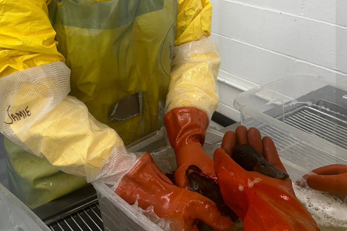
The intersection of the oil plume with regional wildlife corridors created an immediate ecological toll. The Oiled Wildlife Care Network (OWCN), led by veterinarians and specialists from UC Davis, the Aquarium of the Pacific, and International Bird Rescue, established a multi-tiered recovery operation.
- Avian Contamination: Within 72 hours of the rupture, more than 50 oiled birds were identified within the river ecosystem, with at least 25 secured and transported to the Los Angeles Oiled Bird Care & Education Center for clinical stabilization.
- The Mechanism of Injury: Petroleum destroys the hydrophobic microstructure of avian feathers. This structural disruption eliminates the bird's thermal insulation capacity, leading to hypothermia, while simultaneously destroying natural buoyancy. Secondarily, systemic toxicity occurs when the animals attempt to preen their feathers and ingest the crude oil, leading to severe gastrointestinal tract ulceration and acute hepatic failure.
Containment Architecture and Operational Logistical Constraints
Mitigating a multi-jurisdictional aquatic oil spill requires a tiered containment architecture designed to exploit fluid dynamics. The response, managed by a unified command including the U.S. Coast Guard, the California Department of Fish and Wildlife’s Office of Spill Prevention and Response (OSPR), and local hazardous materials teams, deployed defensive and offensive containment mechanisms.
| Containment Layer | Mechanism Deployment | Primary Objective | Operational Limitations |
|---|---|---|---|
| Primary (Source) | Vacuum trucks, absorbent sweeping at Cesar E. Chavez Ave. | Surface recovery of pooled product before storm drain entry. | Limited by rapid gravity migration into subterranean grates. |
| Secondary (In-Stream) | Hydrophobic containment booms across the LA River channel. | Intercepting surface sheen and free-floating petroleum blocks. | Effectiveness decreases if water velocity exceeds 1 knot, causing oil entrainment underneath the boom. |
| Tertiary (Estuary) | High-capacity oil-absorbing booms at the Pacific Coast Highway Bridge (Long Beach). | Establishing a terminal barrier preventing open-ocean entry. | High ambient wind or tidal action can breach the surface seal. |
The primary strategy utilized the density differential between water and petroleum. Because crude oil has a lower specific gravity than water, it remains on the surface of the river. This allows hydrophobic booms—which repel water while absorbing hydrocarbons—to skim the surface.
Mechanical skimming vessels and vacuum infrastructure were positioned upstream of Ocean Boulevard and the Golden Shore areas in Long Beach to strip the oil layer off the moving water column. The structural limitation of this strategy is water velocity: if the river's flow speed exceeds the critical velocity threshold of the boom configuration, the oil layer undergoes entrainment, pulling beneath the physical barrier and continuing downstream.
Long-Term Infrastructure and Operational Upgrades
This incident reveals critical structural vulnerabilities in the intersection of expanding telecommunications infrastructure and legacy energy transmission networks. To minimize the probability of future subsurface asset conflicts, municipal and private operators must transition away from passive utility verification to active, closed-loop coordination models.
The first strategic play requires implementing mandatory Subsurface Utility Engineering (SUE) Quality Level A standards for all directional boring operations within three meters of high-pressure energy corridors. This framework dictates that asset locations must be physically verified via non-destructive vacuum excavation to confirm 3D spatial coordinates before any mechanized drilling commences, eliminating reliance on potentially inaccurate legacy GIS database entries.
The second strategic play demands that pipeline operators update their SCADA automated safety systems to integrate localized pressure-drop anomaly detection algorithms optimized for third-party intervention. If a line experiences a sudden pressure differential matching the hydraulic profile of a mechanical puncture, automated emergency shutoff valves (ASVs) must isolate the affected segment within a 120-second window, drastically curtailing the total potential discharge volume.
Finally, municipal storm water infrastructure within dense utility corridors should be retrofitted with remotely deployable pneumatic sluice gates at key junctions leading to open river basins. In the event of an industrial chemical or petroleum release, emergency services can instantly seal the local storm network, converting the subterranean concrete pipes into temporary containment vaults and preventing open-environment contamination entirely.